EXPOSURES
From transport, energy and fishing to high growth marine sectors of seabed mining, aquaculture and offshore energy, emerging information ecosystems will transform utilisation and sustainability of ocean resources.
In EXPOSURES we demonstrated how on-demand autonomous underwater vehicles (AUVs) can drive intelligent data analytics to rapidly assess environmental processes and impacts in marine waterways. The result help create new marine information ecosystems that exploits underwater IoT infrastructures such as those offered by the European SUNRISE facility.
Big Data Decision Support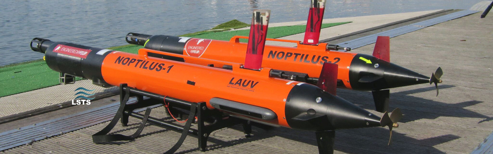
Low cost AUVs, information sharing and fusion the key to rapid insight
Oceans are challenging environments to construct and operate industrial assets. Foundations of offshore structures are vulnerable to localised scour whilst busy navigation channels are subject to ongoing sediment transport. Natural hazards are amplified by extreme weather events and the impact of climate change. Maintaining knowledge about the complex interplay between human activity and micro/macro ecological processes is essential for optimisation of periodic maintenance, response to crisis or extreme weather events, assessment of environment impact and license compliance.
Technology advances within the marine information ecosystem will significantly reduce the time from survey instruction to marine insight. Low-cost drones (autonomous underwater vehicles) and advanced data analytics will seamlessly connect surveyors, marine analysts and decision makers. Drones are now small enough to be launched by one person from the shore and cost less that €100K allowing pre-configuration for marine applications such as scour and sediment transport analysis. Surveyors may no longer need to operate manned sea going vessels and marine surveying may become a land based activity operated by personnel deployed on-demand. Combine the drones with Internet connectivity, geospatial data fusion, and linked data descriptions accessible on the web, and marine analysts will have the information they need for assessing situations rapidly. In addition, ongoing curation of marine information made accessible to teams of analysts through open and closed data policies will increase geo-spatial knowledge and drive improvements in environmental predictions.
We implemented a novel information service platform to provide access to open and closed IoT sources for marine environment analysis and management. The platform uses semantic interoperability and geo-spatial fusion capabilities to collect, semantically represent and align, integrate, aggregate and synthesise large-scale heterogeneous data streams.
The technological innovations include the exploitation of semantic alignment and linked data interface to better expose and exploits data sets' semantic profile and the adoption of scalable array databases solutions for the management of IoT data streams. Through these advances EXPOSURES aimed to:
- increase the efficiency of marine environment analysis through rapid surveying and advanced information services that enrich and fuse heterogeneous data flows
- deliver added value data abstractions applicable to wide range of applications such as localised scouring analysis for wind farm planning and sediment transport analysis
- increase the effectiveness of geospatial analytical tools through risk-oriented high resolution sampling of environment properties
- increase information sharing through alignment with open standards including OGC and W3C
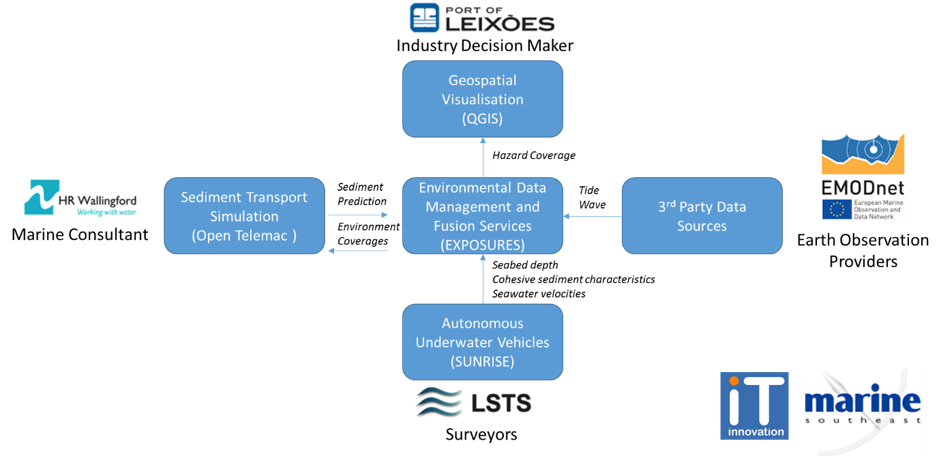
Trial to Maintain Hazard Maps in the Port of Leixoes, Portugal
The emerging data-driven marine industry creates opportunities to address many challenges within the blue economy. From port operations to marine aquaculture and offshore windfarms, these technologies will provide industry with ways to transform risks management for maintenance, crisis and regulatory compliance.
Internet-connected underwater drones (SUNRISE AUVs) send observations to a geo-spatial environmental data fusion platform (EXPOSURES) that prepares data for marine risk analysis (Open Telemac) allowing for rapid response impact analysis. We developed a proof of concept demonstrator that investigated how a representative marine information ecosystems can support industry decision makers and brings together key stakeholders to understand acceptance and emerging business models for commercial viability.
IT Innovation's Role
![]()
IT Innovation has a strong track record in environmental information services and IoT through projects such as SANY, TRIDEC and ENVIROFI.
IT Innovation led the EXPOSURES project, capturing requirements from the marine industry and science stakeholders, and transforming them into capabilities necessary to exploit data sources from the Internet of underwater things. IT Innovation was responsible for all technological aspects of design, development and operations of the EXPOSURES Platform.
Project Fact Sheet
The EXPOSURES project was a 9 month project funded by the EU FP7 "SUNRISE" project.
Coordinator: Marine South East Ltd
Website: http://groupspaces.com/EXPOSURES
More information (SUNRISE): https://cordis.europa.eu/project/rcn/110326_en.html
 EXPOSURES has received EC research funding.